While many appreciate the beauty of wood maps, few understand exactly how they are made. Every miniature curve, detail, and landmark added to a 3D map comes from somewhere—join us as we talk about the historical significance of topography, the exact science of finding different elevations, and how our artists utilize that practice when making the beautiful topographic maps you know and love!
Join us as we pull back the curtain and reveal all the information you could ever want about topography and our wood map creation process. Dive deeper into the cultural significance of maps in history, learn what it takes to draw a topographic map, and get our best tips and tricks for introducing wood map art into your home. Welcome to our behind-the-scenes look at topography—stay a while!
Why Maps Matter

Maps aren't only elegant home décor; they are also one of the most essential advancements for cultures throughout history. Every civilization worldwide has been making some form of map for thousands of years, from the ancient cities of Mesopotamia or the British Empire. Whether discussing modern 3D maps or ancient texts, maps have allowed us to expand our cities and discover new land, directly impacting where we all live now!
When you look at a map, you're getting a look into the past. While maps can be made for countless reasons, like carved wood maps for artistic endeavors or tactile maps for travel expeditions, all maps give us a record of that period of history. Everything from outdated borders to who owns what property and much more are extremely helpful resources.
But maps don't always have to have a life-altering purpose—they can also connect you with your memories. From decorating your house with maps of your hometown to collecting one featuring your favorite travel destinations, wood maps like ours help people reminisce over their favorite memories and vacations, wherever they are.
What Are the Important Elements on a Map?
Each type of map must have some of the same elements so people can follow them easily. Every map, whether a 3D map or a topographic map, generally contains a compass, title, important landmarks, and a legend to give the reader information about any symbols on the map. Whether you're following one for directions or appreciating a wood map in your home, these elements help you know where things are.
Define Topography

Topography, simply put, is the study of the land's surface. Generally, it determines elevations in areas with mountains, valleys, hills, rivers, or lakes. With this scientific approach, someone can look at a piece of land and recreate a perfect 3D map. Studying these elevation changes help scientists study plants and animals and understand the changes the earth goes through.
What is a Topographic Map?
Topographic maps are defined as maps that illustrate the different elevations and shapes on land's surface. Everything from the highest peak to the lowest valley is considered when making these 3D maps. Many also show important man-made works, such as streets, railroads, and major buildings!
5 Popular Methods for Determining Topographic Map Measurements:
Discover the historical techniques and modern advancements of how professionals take topographic measurements when making 3D maps:
Why Do People Use Topographic Maps?

Topographic maps are key to many worldwide businesses. Large-scale architecture firms need access to elevations of land before building. Earth-science-based companies need information on elevations to study the soil, plants, and animals at each location. Even recreational hobbies, like hiking or mountain climbing, need to be able to study these special maps.
On the other hand, there are many aesthetic reasons people know and love these topographic maps. 3D versions of these renditions are popping up as a popular home décor choice, whether they're looking for unique wall art or functional yet beautiful objects around the house. While the study of elevations may have started as a scientific exploration, it's evolved to exist with different 3D art mediums that the everyday person loves to display.
How Are Topographic Maps Drawn?
When creating a topographic map, it all comes down to taking scientific measurements called contours to determine the different elevations in a specific area.
Every new elevation has to have its connected contour line. When contour lines are close together, the slope to the next layer is steep. But if contours are spread out, the increase in elevation is gradual. Anyone can take artistic liberties with their topographic map if the measurements and elevations are distinct.
A topographic map can be just lines and measurements—but what's the fun in that? Map makers use shading, hachure lines, benchmarks, and more to signify subtle details in an area's elevation.
5 Rules for Topographic Maps

After a scientist takes the measurements of the land they’re studying, they have to draw it as a 2D map. There are many different styles of topographic maps, but they generally depend on these five rules:
- Every point on a contour line is the same elevation.
- Contour lines can never cross or separate.
- Every fifth contour line must be bold and labeled with the elevation number.
- Spots where the land dips down are shown with small hachure marks.
- Scales to indicate horizontal distance should be put in the legend.
Are All Topographic Maps 3D?
Not all topographic maps are made into 3D maps. Topographic maps can be completely flat, using only the interpretation of contour lines to portray the elevations. 3D maps are visual representations that show a dimensional version of a topographic map. Instead of having you interpret each distance, a 3D map gives you a physical recreation of that area!
Why We Love Designing Wood Maps
There's something beautiful and special about filling your home with art you connect to. We take pride in creating sophisticated, long-lasting wood maps of your favorite locations. Fill your home with our 3D maps to completely personalize your home décor and appreciate the perfect blend of topographic science and art.
Wood maps are a simple yet elegant way to feel connected to the items in your home. When you hand-select a 3D map of a destination with meaning, whether it be a favorite vacation or a loved one's hometown, you can show off your style and fill your home with meaningful objects.
How Our 3D Wood Maps Are Made

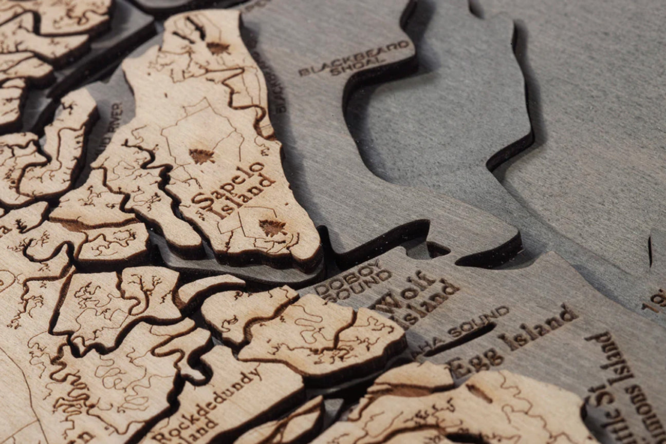
When you look at a 3D map and notice every tiny detail, it may seem like it'd be impossible to make. But, with the advancements in laser technology, companies like ours can easily create replicas of all your favorite locations! At Wood Chart, we use a combination of special wood lasers and colorful stains to create the different wood maps you know and love.
When our artists first select a destination, they begin by looking at readings from a bathymetric chart (depicting the elevations of bodies of water). Those depth and dimension measurements are put into the highly advanced laser cutter. The laser carefully cuts each piece out of the wood into each elevation layer. After they are all cut, the artist hand layers each piece with a special glue to make the 3D map.
Afterward, our brilliant artists take this process to another level to beautify the wood map even further. Each area of the map representing water, whether a river, lake, or ocean, is hand-stained with a rich blue-green color. For even more detail, that location's meaningful landmarks and main roads are laser engraved into the surface. Once they're placed behind acrylic glass and into a custom frame of your choosing, they are ready to go!
5 Popular Materials for Topographic Wood Maps:
3D maps are available in countless styles, so there's a perfect map for every home. We prefer the classic and durable birch wood when we make our 3D topographic maps, but many companies use these alternatives:
- Foam
- Plastic
- Wood
- Metal
- 3D printers
Why You Should Decorate with Wood Maps

Even if the scientific elements don't excite you, wood maps are among the most beautiful and fascinating visual art forms. When decorating your home, skip the same-old prints from big-box retailers—take a chance with a unique and intricate 3D map. From classic wood grains to velvety blue colors, our wood charts instantly elevate any room in your home.
Wood maps are a beautiful souvenir for any vacation. Whether you're looking for a Lake Tahoe souvenir or planning a once-in-a-lifetime trip to Italy, we have countless designs to commemorate your travels. When you invest in something made with such high-quality materials and attention to detail, you'll be able to remember your trips fondly and enjoy them in your home for years to come.
Wood maps also make the perfect home décor or gifts for loved ones of all ages! Every beautiful contour curve and landmark doubles as a stunning detail and a built-in geography lesson. When you have a meaningful wood map in your room, you can have fun pinpointing exactly where that beach house was or where your family plans to travel. Who knows—maybe one day, that Great Lakes chart will be a prized family heirloom!
Decorate Your Home with 3 Types of Wood Maps:
Any room in your house can be enhanced when you have a wood map you love—and we have the topography to thank! From gorgeous wall art to fun and special cribbage boards, you can improve your life and home decor with our best 3D map designs.
1. Elevate Your Rooms with Wood Map Wall Art

Adorning your wall with timeless 3D maps is an easy way to change the atmosphere of any room. Put up your favorite large Puget Sound chart as the star of the show in your entryway, or feature a few smaller topographic Catalina Island maps on the gallery wall in your living room. These wood pieces will give any home decor style a pop of texture and color.
Not to mention that you'll have an instant conversation starter. When a guest sees your favorite wood map, they'll be inspired to ask questions about why you chose that specific location, giving them a chance to tell all your favorite stories and explain why that spot is so meaningful to you!
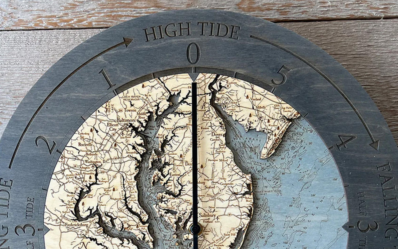
2. Decorating with Wood Map Wall Clocks
Our vast collection of topographic-designed wall clocks is full of best-sellers for a reason. Not only are they a genius way to make an otherwise simple piece of home décor beautiful, but they're also incredibly useful. Hang one up in your home or bring one to your place of work to enjoy the beauty from your desk. When you hang an Ireland Clock, you'll count down the seconds until your next adventure!
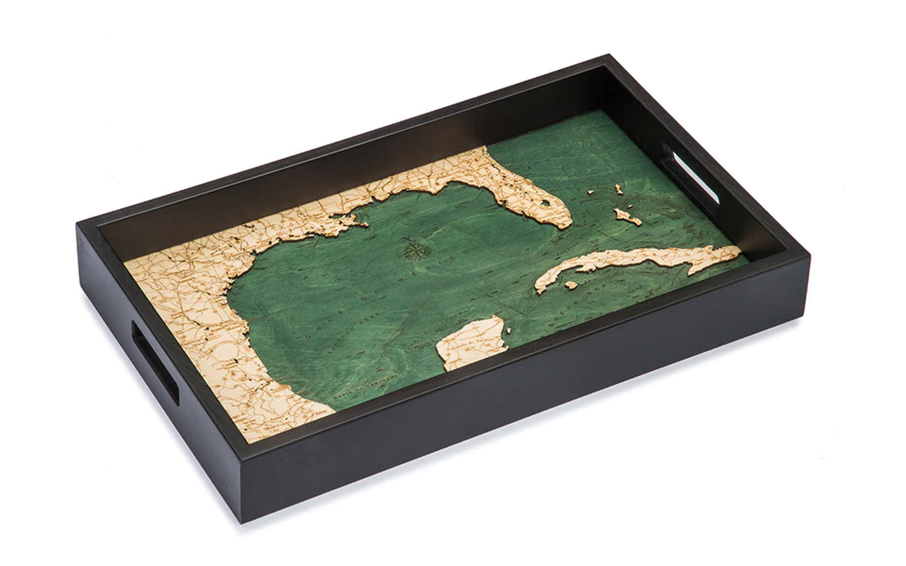
3. The Versatility of 3D Map Serving Trays

What better way to show off the stylish blend of topography and wood maps than our serving trays? These are the most versatile design we carry, so feel inspired to find the uses for your Boston Harbor tray as you see fit. Serve appetizers at an intimate gathering, corral remotes on your coffee table, or house your favorite perfumes and lotions at your vanity. Whenever you use a 3D map serving tray, you'll enjoy your memories of that location all over again.
Humans are inexplicitly drawn to maps. Kids play with scavenger hunt maps at a young age, and many adult professions rely on looking at or creating maps. Some of us rely exclusively on phone GPS systems to travel around. Whether searching for the unknown or looking to illustrate your travels, maps are essential in our lives. And whether you know it or not, topography is to thank!
From dissecting the social significance of maps throughout time to understanding the rules for drawing a topographic map, you may feel inspired to hang up a wood map of your own. Think about your favorite destinations, from the city you were married to a dream vacation. Appreciate our artist's commitment to interpreting topographic measurements to create high-quality 3D maps and browse our different collections and product types to find a meaningful map you'll love to look at for years.