


Molly H.09 · 22 · 2022
★★★★★
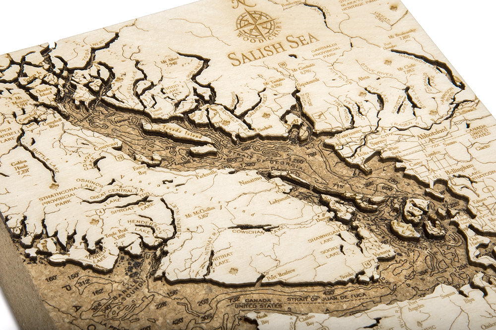
I love this area around Seattle/Vancouver, so I was thrilled to find a work of art in the form of a cork map. This is a very cool item. The detail on the carving is amazing. Also like that it can stand alone on a shelf. Love it!
Looks great, exactly as pictured. Only downside was the sticker on the back is a bit hard to remove.
Beautiful product, arrived on time and exactly as described. You can feel the quality when you pick it up - thank you!
High quality. One very small peninsula broke off during shipping, but was in the box and easily reattached.
It was just as mentioned on site and absolutely stunning in person.
This was a gift and they absolutely loved the gift.
This is beautiful and my son was so happy to get it for Christmas.
Ordered as a gift and it delivered to the recipient very quickly. I haven't seen it in person, but my Uncle loves it!!
Great product. Would recommend for gifts!
The item arrived quickly and the box is in great shape. Excellent, as it's a Christmas gift!
Quick delivery. Great quality. Great representation of the PNW.
Thank you for the things I have. I like them very much
I still haven't given it to my husband, but wanted to open it so I could finish the reviews. The infinite detail brought tears to my eyes. Will be perfect here in our summer condo on the Salish Sea. And will take it with me to our home in Arizona as a great reminder of our times there.
Fast shipping, very reasonably priced & will buy again! Thank you.
This cork-backed map of the Salish Sea is as nice as I'd hoped it would be. I put the map in my office at work and everybody who visits me notices, comments, and asks where they can get one! I am very pleased with this item.
A great gift and good quality.
Very cool. And great value for the money. My dad loves it!
Totally amazing. So we'll done. A very nice piece to show.
Nice quality, fast shipping! Very please with this product!
Everything about this is great. We bought these to be used as departing gifts for our Coast Guard Unit here in the Puget Sound. Everyone loves them! The quality is very good and everything arrived exactly when it was supposed to! The only other Cork map of the Puget Sound that I found available was $45 and these are only $20! We are so happy, we will be ordering more!
My husband loved his gift! I was thrilled at how quickly it arrived.
Beautiful and detailed!
Very happy with item!
Satisfied with the quality of this product. I recommend it if you want something done well and for a good price.
This made a great gift for a map aficionado - so unique and works well as a home decor piece. I gave it 4 stars rather than 5 because the cork piece is so thick - about 4 inches thick - all that extra is unnecessary for the carving or structural stability of the item and seemed like unfortunately a bit of a waste of a natural resource.
Great quality with clear, easy to read detail. I like how it stands on it's own on a shelf!
This is beautiful and well made. It shipped ASAP too which was awesome!!!
very cool 3-d map. like it