WoodChart
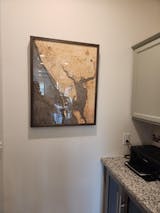
Charlotte Harbor, Florida 3-D Nautical Wood Chart, Large, 24.5" x 31"
- Regular price
- $425.00
- Sale price
- $425.00
- Regular price
From romantic getaways to retirement destinations, Charlotte Harbor is one of the most recognized places in the world to escape from the world around you. The natural shorelines and athletic opportunities provide a beautiful mix of adventure and relaxation for people of all ages.
Charlotte Harbor sits between Punta Gorda and Port Charlotte on the southwest coast of Florida. The sunsets and white sand beaches create a magnificent escape for couples, while the miles of shoreline make this a great destination for boating and fishing. Charlotte Harbor is a natural estuary and an incredible wetland, creating natural ecosystems for plants and wildlife.
Our 3D nautical wood map of Charlotte Harbor begins with layers of Birch that are laser cut and glued together to form the intricate shoreline the area is known for and add a vibrant dimension to the framed piece. The water is hand-stained, and points of interest, roads, and ocean depths are etched into the map’s surface. The 3D nautical wood map is finished with a custom wood frame and a durable acrylic cover for protection.
Inspire future fishing trips to Charlotte Harbor with this beautiful 3D wood map.
Points of Interest on Charlotte Harbor Wood Map:
Englewood, North Port, Peace River, Pine Island, Port Charlotte, Punta Gorda, and Venice
- Made of High-Grade Birch
- Solid wood frame made to fit
- Laser-cut depth
- Engraved names and locations
- Acrylic glass protection
- Arrives ready to hang
- Dark Brown Frame, Greenish Blue Water
- Rustic Grey Frame, Greyish Blue Water
- White Frame, Greyish Blue Water


