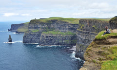
Get out your Ireland map and pick any destination on the island; you will not be disappointed! It is impossible to visit Ireland and not feel the pulse and pull long after you have gone. The Emerald Isle is best known for its wit, humor, and craic, giving it the well-earned reputation of a neutral country full of love and hospitality for all who visit.

The people of Ireland are accustomed to the rain and short summers, so they use any long sunny day to venture to one of the coasts to soak up the sun and having spontaneous parties.
The Irish Sea is along the east coast, separating Ireland and Great Britain. Covering over almost 18,000 square miles, the Irish Sea is surrounded by Scotland, Wales, England, and Ireland. Also referred to as the Manx Sea or the Celtic Sea, this body of water can give you at least nine good reasons to hightail it to the land of saints and scholars.
Our Top 9 Irish Sea Facts
- Titanic was made on the shores of the Irish Sea
- The Irish Seas has More than 50 Islands
- Offshore Wind Farms are Generating Goodwill
- Leatherback Turtles Make an Appearance in the Summer
- Perfect for Recreational Water Sports
- Home to Four Major Coastal Cities
- Find the Basking Shark in the Irish Sea
- A Dumping Ground for Undetonated Munitions
- You can Buy a Castle by the Irish Sea
1. The Birthplace of the Titanic is on the Shores of the Irish Sea
The Titanic was built in Belfast at the shipyards of Harland and Wolff. The White Star Line commissioned the largest ships built at that time – the Titanic and her sister ship, the Olympia. With no expense spared, the Titanic was completed in 1912.
 Any Ireland map will show the depths of the sea near the northeastern coast of Ireland that created the perfect waterways in which to motor this triumphant vessel. Her seaworthiness was tested, and shortly after that, she set off to sea from Cobh on April 11, 1912, at 1:30 p.m. The world got its last look at her as she sailed from Cobh on her maiden and only voyage.
A trip to Belfast is incomplete without venturing into a few of the Titanic museums, especially the Titanic Belfast exhibit. If you haven’t a baldy notion about the basic story of the Titanic, we will have to ask that you at least see the movie before your wee journey!
2. The Irish Sea has More Than 50 Islands
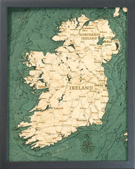
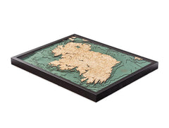
Easily seen in the bathymetry (underwater topography) of an Ireland wooden map, the sandbanks and the depths of the sea create and uncover more than fifty islands, a few of which are inhabited.
The Isle of Anglesey, just off the Wales coastline, is the largest island in the Irish Sea at 260 square miles. At last count in 2011, almost 70,000 people live on Anglesey, and most speak Welch. These islanders travel back to the mainland of Wales on the Menai Suspension Bridge, recently rebuilt in 1980.
As of 2016, just over 83,000 people inhabit the most populous island – the Isle of Man. A self-governing British crown dependent, Mann relies on the British government for oversight, and Queen Elizabeth II holds the title Lord of Mann. She is represented there by a lieutenant governor. Independent, but overseen; far away but connected.
The Isle of Man is an exciting destination boasting international renown for TT motorcycle racing and the Manx cat, a breed with a short or no tail.
3. Offshore Wind Farms are Generating Goodwill
In 2018, the world’s largest offshore wind farm opened in the Irish Sea. Covering an area that is more than double the size of Manhattan, this farm generates enough energy to power over 590,000 homes. Wind power generation is essential in Ireland because the country lacks fossil fuel resources, and the extensive supply of wind is sustainable.

An Ireland map will show ample shoreline to choose from for creating wind farms, but offshore wind farms have become more of the norm. Though the Atlantic coastline has higher winds, the shallower waters of the Irish Sea shoreline are easily seen on an Ireland wooden map, making those waters more desirable.
Wind farms create more than just energy; they generate jobs and enhance tourism. The Bord Na Mona wind farm in County Offaly created a walkway through their park for walking, cycling, and running. This clean, safe space attracts locals and tourists alike, resulting in dollars spent in the local community at the pubs and shops. The answer to climate change, my friend, could be blowing in the winds of Ireland!
4. Elusive Leatherback Turtles Swim Through Every Summer
Leatherback turtles are frequently found in the waters surrounding Ireland and Wales. In 1998, the largest leatherback ever recorded was found in North Wales, measuring nine and a half feet and weighing in at 2,016 pounds! It is hard to imagine how a turtle can grow to such a size while consuming mostly jellyfish, which are primarily made of water.

Are leatherbacks innately wanderers, or are they genuinely part of the Irish heritage? Primarily seen in the summer months in the waters near Northern Ireland, leatherbacks spend most of their year in the open ocean, diving and swimming to catch the tempting treats of the deep: jellyfish and squid.
If you plan your trip between July and September, keep your eyes open for these elusive and majestic creatures in the Irish Sea.
5. You Can Enjoy Popular Recreational Sports on the Irish Sea
There are many popular recreational sports enjoyed on the Irish Sea throughout the year. As the underwater topography on an Ireland wood map will reflect, the shallows and the depths provide ample options for enjoyment, whether on top of the water or exploring down below. Sailing, swimming, kayaking, and scuba diving are incredibly popular in the Irish Sea.
With the underwater hills and valleys seen on the Ireland wooden map, you can visually trace your adventures and see just how deep the water was around you as you braved the cold and unknown. Of course, angling is a hugely popular pastime along the diverse coast of the Irish Sea. Some of the most common fish caught off the west coast include:

- mackerel
- turbot
- plaice
- dogfish
- sea bass
Armed with steel will and a sturdy wetsuit, you can enjoy any of these sporting activities year-round. However, you can also enjoy a pint in a pub, cozied up next to a fire during the colder months. Irish whimsy is strongly encouraged.
6. The Irish Sea Has 4 Major Coastal Cities
With its shores bordering four countries, the Irish Sea has many bustling seaports and thriving cities. Of course, we love the lush landscape of Ireland, but there are English cities that line the Irish Sea as well. The largest English cities that line the Irish Sea are:
- Dublin
- Liverpool
- Belfast
- Blackpool
As you can see on any Ireland map, Dublin is the largest city and capital of Ireland. Home to 1.9 million people and the stunning, historic Trinity College, Dublin is the center for arts, education, administration, and industry. Shopping, entertainment, and music inhabit every corner, and a trip to the Guinness or Jamieson factories is a high priority.
Liverpool is a city and borough in England. Widely known for the arts and The Beatles, Liverpool cemented itself in popular culture. While The Beatles are their biggest claim to fame, Liverpool has continued to produce many notables for the arts, sports, and writing ventures.

On the northeast side of the Ireland map, you will find Belfast. The second-largest city on the island, Belfast remains significant in port trade and shipbuilding. It has never quite emerged from the shadows of its reputation as home to the world’s largest shipyard and the birthplace of the Titanic. However, Sons of Anarchy fans might know the large city for other reasons!
Blackpool is a large town and seaside resort on the northwest coast of England. Though the days of being a locals-choice resort have passed, Blackpool still welcomes millions of visitors each year.
Before air travel became affordable, locals, particularly factory workers from Northern England, flocked to the beaches of Blackpool. Despite the increase in travel options and destinations, Blackpool remains the most popular seaside resort in the United Kingdom.
A bonus wee fact – get out your Ireland map, close your eyes, and point to anywhere on it; you will find a city full of history, beauty, and the most welcoming friends you haven’t met yet.
7. The Second-Largest Shark Swims in the Irish Sea
Over thirty-five fish species have been recorded as swimming in the Irish Sea, including the second-largest shark in the world –the basking shark. Please do not be intimidated by its size! The basking shark is the least dangerous to swim with, as it only feeds on tiny zooplankton and invertebrates.

Basking shark season starts in April and runs through late July, allowing visitors on water and land to get a glimpse of this gentle creature. Growing up to thirty feet long, basking sharks are second in size only to the whale shark. Their size will leave you in awe of how they can navigate the waters of the Irish Sea.
An Ireland wooden map will show the depths and shallows of the waterways, allowing you to track the shark’s path and better understand the deep water available to accommodate a behemoth such as the basking shark.
8. There are Mysteries in the Deepest Waters of the Irish Sea
Beauford’s Dyke is a thirty-mile channel that runs between Northern Island and Scotland. Part of the Irish Sea, the dyke reaches depths of 700-1,000 feet and a width of two miles. The depth is keenly seen in the topography of an Ireland wooden map, clearly marking this area as “perfect” for dumping undetonated munitions after the first and second world wars.
While it is specifically unknown what type of munitions and how many were submerged after WWI. It is recorded that after WWII, items dumped into the Irish Sea include:
- mortars
- grenades
- rockets
- cluster bombs
- anti-aircraft shells
While there is some debate as to whether these items are harmful, they are impeding building a tunnel or other access way between Northern Ireland and Scotland.
Consult your Ireland wood map and see the amazing depth of Beauford’s Dyke. You will want to keep the depth of the dyke in mind as you wander along the shoreline. Should you see a foreign object sticking out of the sand, resist the urge to kick it! It is not uncommon to find undetonated munitions from the depths of Beauford’s Dyke while sunbathing along the shore!
9. You Can Buy a Castle and Live Near the Irish Sea
Who does not want to live in a castle? Consult your Ireland map and head out in any direction to see many castles dotting the landscape. Whether historic ruins or meticulously maintained estates, the lure of castle life is strong. And you can buy your very own castle right on the shores of the Irish Sea.
Inniscorrig Castle was originally built around 1847 as a summer retreat for a Dublin physician. Only thirty miles from Dublin, this castle boasts substantial property and panoramic water views, with direct access to the Irish Sea.

Imagine shepherding your guests to one of the five bedrooms, keeping the one in the tower for yourself. Check your itinerary—a trip to the Emerald Isle now includes a stop at the local real estate office.
A visit to Ireland is an adventure your heart will never forget. There are many mountains and cliffs to explore, too many for just one trip; you will be planning your next adventure before your plane takes off from Dublin Airport.
Your experience can only be matched by the excellence of the Ireland wood map to commemorate your vacation. Purchased from a quality purveyor, your map will give depth, drama, and relief to the visions in your head, the land you crossed, and the waterways you explored.
Once you have visited the magical, mysterious Land of Saints and Scholars, there is only one way to honor the sheer beauty of what you witnessed, and that is with a quality wood map made with exacting precision and crafted with quality. Gazing at your Ireland map in your home is the next best thing to living in Ireland, in a castle next to the Irish Sea. There are many more European nations to explore, so grab your bags and your wood map and find your next destination.